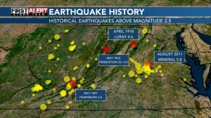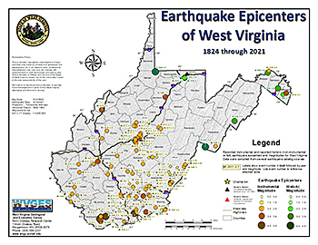
Natural earthquakes indicate areas of possible further seismicity (Click map to enlarge this area of WV & VA)
.
.
From a Broadcast Message by Will DuPree, KXAN News, November 17, 2022
.
REEVES COUNTY, Texas (KXAN) — The third-strongest earthquake in Texas state history struck on November 16 in the afternoon in West Texas followed by a less powerful one about an hour later.
TexNet, the state’s earthquake monitoring network, reported both earthquakes happened in rural Reeves County. The first one registered at a magnitude 5.3 and hit at about 3:32 p.m. near Mentone. More shaking began at 4:39 p.m. when TexNet recorded a magnitude 4.1 earthquake close to the town of Pecos. Both communities are about 27 minutes apart by car.
The Railroad Commission of Texas, the state’s regulatory agency over the oil and gas industry in the state, announced Thursday it’s sending inspectors to Reeves County after the earthquakes and promised to take any action for disposal wells in the area.
“RRC inspectors are examining disposal activity at injection wells in the area,” a news release detailed, “and staff is also reviewing permit requirements and operators’ seismic response plans in the Northern Culberson-Reeves Seismic Response Area (SRA).”
Dr. Scott Tinker serves as director of UT Austin’s Bureau of Economic Geology, which runs the TexNet service. He said he’s glad to hear the RRC is sending a team to the area where the two earthquakes happened. He said it’s too early to say definitively what the cause is, but he suspects “more likely than not that this is something induced by that kind of water disposal” related to oil and gas production.
“We’ve been doing a pretty detailed job of mapping all those faults in West Texas and across Texas now with some high-level experts, mapping those and creating much more detailed fault maps to understand those planes and helping the commission to regulate where the water disposal happens and keep away from some of those higher-likelihood points of weakness,” Tinker said.
He said he also thinks two fairly large earthquakes happening in close proximity and time to each other will factor into possibly changing where these disposal activities are allowed to happen in West Texas.
“Those who are disposing have to do a lot of things ahead of time before they can put water down in seismically-restricted areas,” Tinker said. “So this kind of effort, this TexNet effort has helped to better manage and try to mitigate these kinds of earthquakes.”
The initial data showed the two quakes happened at 30,512 and 24,278 feet underground respectively, according to TexNet. That’s about eight miles below the surface.
People living in different parts of Texas, including as far as Austin, reportedly felt the effects of that initial magnitude 5.3 earthquake. Experts at the U.S. Geological Survey have a form available online where people can report where they live and whether they felt the shaking from this earthquake.
The state legislature created the TexNet service in 2015 to buy, install and maintain a statewide network of earthquake monitoring stations. Those then feed seismic data to a central hub housed at the Bureau of Economic Geology located at the University of Texas at Austin. 
+++++++
Seismic monitoring is ongoing at the WV Geological Survey (WVGES) located at Mt. Chateau on Cheat Lake. The 5.8 magnitude earthquake that occurred at Mineral, Virginia, in August of 2011 was detected by the WVGES.

{ 2 comments… read them below or add one }
2011 Virginia earthquake of Magnitude 5.8
From Wikipedia, the free encyclopedia
UTC time 2011-08-23 17:51:04
ISC event 17331323
Local date August 23, 2011, Local time 1:51:04 pm EDT
Magnitude 5.8 Mw, Depth 6 km (4 mi)
Epicenter 37°56′10″N 77°55′59″W
Type Dip-slip (reverse)
Areas affected Canada, United States
Max. intensity VIII (Severe)
Peak acceleration 0.26 g
Casualties Several injured. On August 23, 2011, a magnitude 5.8 earthquake hit the Piedmont region of the U.S. state of Virginia at 1:51:04 p.m. EDT. The epicenter, in Louisa County, was 38 mi (61 km) northwest of Richmond and 5 mi (8 km) south-southwest of the town of Mineral. It was an intraplate earthquake with a maximum perceived intensity of VIII (Severe) on the Mercalli intensity scale. Several aftershocks, ranging up to 4.5 Mw in magnitude, occurred after the main tremor.
The quake was felt across more than a dozen U.S. states and in several Canadian provinces, and was felt by more people than any other quake in U.S. history. No deaths and only minor injuries were reported. Minor and moderate damage to buildings was widespread and was estimated by one risk-modeling company at $200 million to $300 million, of which about $100 million was insured.
The earthquake prompted research that revealed that the farthest landslide from the epicenter was 150 miles (240 km), by far the greatest landslide distance recorded from any other earthquake of similar magnitude.
Previous studies of worldwide earthquakes indicated that landslides occurred no farther than 36 miles (58 km) from the epicenter of a magnitude 5.8 earthquake. The Virginia earthquake study suggested that the added information about East Coast earthquakes may prompt a revision of equations that predict ground shaking.
Earthquakes Due To Fracking Not Uncommon
Significant back-to-back earthquakes in northern British Columbia (B.C.) ‘very likely’ caused by fracking: federal expert. 4.6 and 4.7 magnitude quakes northwest of Fort St. John recorded within four days, just a kilometre apart.